A simplified vegetation map
Description
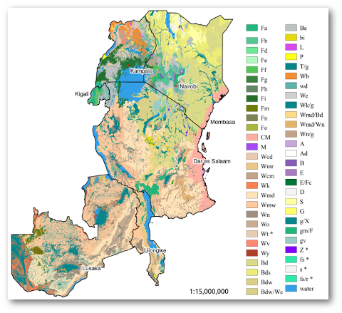
Spatial data layer containing a aggregated version of potential natural vegetation map of eastern Africa. Used as baseline data in the PLoS ONE publication “Environmental gap analysis to prioritize conservation efforts in eastern Africa”.
This data set consists of a spatial data layer (raster layer at geotif format) describing the potential natural vegetation of eastern Africa (Kenya, Uganda, Tanzania, Rwanda, Malawi, Zambia). The map is a simplified version of the potential natural vegetation map for eastern Africa developed by the Vegetationmap4africa group.
For most analyses one would probably prefer the more detailed original map. However, there are a number of characteristics of the origal map that need to be taken into account when used for analysis:
- Not all PNVs were consistently mapped across the region. A number of the vegetation types were mapped in one country individually, while mapped as part of a more aggregated vegetation type in other countries. This was done to maintain the maximum level of information available. However, this may be sub-optimal for regional level assessments.
- There are a number of areas where the vegetation was classified as a compound vegetation type, i.e., consisting of two or more vegetation types. In these cases the existing historical maps, documentation and available expert knowledge was not conclusive as to the exact nature of the potential natural vegetation in that area. For estimations of e.g., area statistics one would ideally be able to classify each location as a unique PNV.
The objective of the work presented in this manuscript was therefore to create a layer that address these issues, while retaining as much as possible of the details of the original map. To achieve this, we:
- Harmonized the vegetation classification across the different countries in the eastern Africa region by aggregating country specific vegetation types into regional types;
- Split compound vegetation types into unique PNVs, using environmental distribution modelling based on the distribution of the PNVs in the original map.
File set
The the data layer (a raster file in geotif format) and accompanying metadata is available on Figshare. See the accompanying manuscript for details about the methods used to create the data.
If you use the data, we are requesting you to notify us of the intended use. You can download the data and manuscript here.