Online map
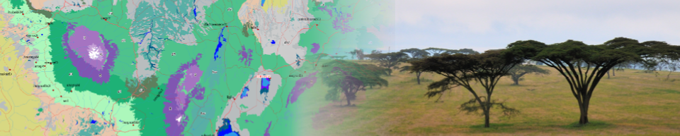
Now you can also explore the map from within your browser. In the map you’ll see the vegetation type at the position of your mouse point. To get more information about the vegetation at any location, double click the map, and a pop-up will show with the vegetation name and a link that will open (in a separate tab/window) a fact sheet with a concise description of that vegetation type and a list of species naturally occurring in the selected potential natural vegetation type. Click here for an overview of the map features.
We are currently updating and redesigning the online map. As an alternative, you can check the Google Earth overlay, request a copy of the data, or check the book volumes
Please note that the information here is provided ‘as-is’, and does not come with any warranty or guarantee of any kind. Please also note that the material and geographic designations in this dataset do not imply the expressions of any opinion whatsoever on the part of the authors concerning the legal status of any country, territory or area, nor concerning the delimitation of its frontiers or boundaries. Use of the information, including derived products, must include appropriate citation as provided below.
Citation: van Breugel P, Kindt R, Lillesø JPB, Bingham M, Demissew S, Dudley C, Friis I, Gachathi F, Kalema J, Mbago F, Moshi HN, Mulumba, J, Namaganda M, Ndangalasi HJ, Ruffo CK, Védaste M, Jamnadass R and Graudal L (2015) Potential Natural Vegetation Map of Eastern Africa (Burundi, Ethiopia, Kenya, Malawi, Rwanda, Tanzania, Uganda and Zambia). Version 2.0. Forest and Landscape (Denmark) and World Agroforestry Centre (ICRAF). URL: https://vegetationmap4africa.org