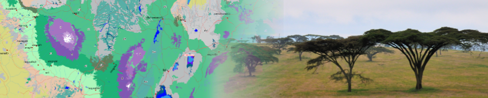
Species distribution maps
Below a list is provided of 1,022 plant species that are documented in species assemblages for the potential natural vegetation map. For each the species, a list is provided of the vegetation types in which a species is expected to be present. The distribution of each species in vegetation types for each species was classified as characteristic, present or marginal.
Instruction
Clicking on a link below will download a Google Earth point layer. If you have installed Google Earth Pro, the downloaded layer will automatically open in Google Earth.
Alternatively, you can start Google Earth in your browser (click here). Next, click on Projects (5th icon in the side bar), and next click the button New Project. Select the option Import KML file from computer, and open the KML file you just downloaded.
The kml file consist of a point layer. The points form a 5km grid representing the distribution of the vegetation types in which the species is expected to occur (i.e., the points do not represent actual observations of species occurrences). Clicking on any of the points will open a popup with the links to the factsheets of the corresponding vegetation types.
Species list
A - B - C- D - E - F - G - H - I - J - K - L - M - N - O - P - R - S - T - U - V - W - X - Z
- Abutilon angulatum
- Acacia abyssinica (Vachellia abyssinica)
- Acacia asak (Senegalia asak)
- Acacia ataxacantha (Senegalia ataxacantha)
- Acacia brevispica (Senegalia brevispica)
- Acacia bussei (Vachellia bussei)
- Acacia drepanolobium (Vachellia drepanolobium)
- Acacia edgeworthii (Vachellia edgeworthii)
- Acacia ehrenbergiana (Vachellia flava)
- Acacia elatior (Vachellia elatior)
- Acacia erioloba (Vachellia erioloba)
- Acacia etbaica (Vachellia etbaica)
- Acacia fleckii (Senegalia fleckii)
- Acacia galpinii (Senegalia galpinii)
- Acacia gerrardii (Vachellia gerrardii)
- Acacia hockii (Vachellia hockii)
- Acacia horrida (Vachellia horrida)
- Acacia kirkii (Vachellia kirkii)
- Acacia lahai (Vachellia lahai)
- Acacia malacocephala (Vachellia malacocephala)
- Acacia mearnsii
- Acacia mellifera (Senegalia mellifera)
- Acacia nigrescens (Senegalia nigrescens)
- Acacia nilotica (Vachellia nilotica)
- Acacia oerfota (Vachellia oerfota)
- Acacia paolii (Vachellia paolii)
- Acacia polyacantha (Senegalia polyacantha)
- Acacia pseudofistula (Vachellia pseudofistula)
- Acacia reficiens (Vachellia reficiens)
- Acacia robusta (Vachellia robusta)
- Acacia senegal (Senegalia senegal)
- Acacia seyal (Vachellia seyal)
- Acacia sieberiana (Vachellia sieberiana)
- Acacia tanganyikensis (Senegalia tanganyikensis)
- Acacia thomasii (Senegalia thomasii)
- Acacia tortilis (Vachellia tortilis)
- Acacia xanthophloea (Vachellia xanthophloea)
- Acacia zanzibarica (Vachellia zanzibarica)
- Acalypha chirindica
- Achyranthes aspera
- Achyrocline glumacea (Helichrysum glumaceum)
- Acokanthera oppositifolia
- Acokanthera schimperi
- Acroceras macrum
- Acrostichum aureum
- Adansonia digitata
- Adenia globosa
- Adenium obesum
- Adenocarpus mannii
- Aerva javanica
- Aeschynomene abyssinica
- Aeschynomene cristata
- Aeschynomene elaphroxylon
- Aeschynomene pfundii
- Aeschynomene schimperi
- Aframomum alboviolaceum
- Afrocarpus falcatus
- Afrocarpus usambarensis
- Afzelia quanzensis
- Agauria salicifolia (Agarista salicifolia)
- Alangium chinense
- Albizia adianthifolia
- Albizia amara
- Albizia anthelmintica
- Albizia antunesiana
- Albizia coriaria
- Albizia glaberrima
- Albizia grandibracteata
- Albizia gummifera
- Albizia harveyi
- Albizia malacophylla
- Albizia petersiana
- Albizia schimperiana
- Albizia versicolor
- Albizia zimmermannii
- Albizia zygia
- Alchemilla argyrophylla
- Alchemilla elgonensis
- Alchemilla johnstonii
- Alchornea hirtella
- Alchornea occidentalis
- Allanblackia stuhlmannii
- Allophylus abyssinicus
- Allophylus africanus
- Allophylus rubifolius
- Aloe breviscapa
- Aloe kedongensis
- Aloe rigens
- Aloe scobinifolia
- Alstonia boonei
- Amblygonocarpus andongensis
- Andropogon brazzae
- Andropogon greenwayi
- Andropogon kelleri
- Andropogon schirensis
- Anisophyllea boehmii
- Annickia kummeriae
- Annona senegalensis
- Anogeissus leiocarpa (Terminalia leiocarpa)
- Anonidium usambarense
- Anthocleista grandiflora
- Anthocleista schweinfurthii
- Anthonotha pynaertii
- Antiaris toxicaria
- Antidesma venosum
- Aphania senegalensis (Lepisanthes senegalensis)
- Apodytes dimidiata
- Aporrhiza nitida (Aporrhiza paniculata)
- Aristida adscensionis
- Aristida mutabilis
- Aristida stipitata
- Aspilia mossambicensis
- Avicennia marina
- Azima tetracantha
- Baikiaea insignis
- Baikiaea plurijuga
- Baissea wulfhorstii
- Balanites aegyptiaca
- Balanites glabra
- Balanites maughamii
- Balanites pedicellaris
- Balanites rotundifolia
- Balanites wilsoniana
- Balthasaria schliebenii
- Baphia abyssinica
- Baphia burttii
- Baphia massaiensis
- Barleria prionitis
- Barleria proxima
- Barringtonia racemosa
- Bauhinia petersiana
- Bauhinia taitensis
- Beilschmiedia ugandensis
- Berberis holstii
- Berchemia discolor
- Berlinia giorgii
- Bersama abyssinica
- Bivinia jalbertii
- Blepharis acanthodioides
- Blepharis linariifolia
- Blepharis maderaspatensis
- Blighia unijugata
- Bobgunnia madagascariensis
- Bombax buonopozense
- Borassus aethiopum
- Boscia albitrunca
- Boscia angustifolia (Maerua gilgii)
- Boscia coriacea
- Boscia salicifolia
- Boswellia microphylla
- Boswellia neglecta
- Boswellia papyrifera
- Boswellia rivae
- Bothriochloa bladhii
- Brachiaria brizantha
- Brachiaria humidicola (Urochloa dictyoneura)
- Brachiaria jubata (Urochloa jubata)
- Brachylaena huillensis
- Brachystegia allenii
- Brachystegia bakeriana
- Brachystegia boehmii
- Brachystegia bussei
- Brachystegia floribunda
- Brachystegia glaucescens (Brachystegia tamarindoides)
- Brachystegia longifolia
- Brachystegia manga
- Brachystegia microphylla (Brachystegia tamarindoides subsp. microphylla)
- Brachystegia puberula
- Brachystegia spiciformis
- Brachystegia stipulata
- Brachystegia taxifolia
- Brachystegia utilis
- Brachystegia wangermeeana (Brachystegia tamarindoides)
- Breonadia salicina
- Bridelia brideliifolia
- Bridelia micrantha
- Bridelia scleroneura
- Bridelia taitensis
- Bruguiera gymnorhiza
- Buddleja polystachya
- Burkea africana
- Burttdavya nyasica (Nauclea nyasica)
- Burttia prunoides
- Bussea massaiensis
- Cadaba farinosa
- Cadaba glandulosa
- Cadaba heterotricha (Cadaba linearifolia)
- Cadaba mirabilis
- Cadaba rotundifolia
- Caesalpinia decapetala (Biancaea decapetala)
- Caesalpinia trothae (Gelrebia trothaei)
- Caesalpinia volkensii
- Calodendrum capense
- Calotropis procera
- Calyptrotheca somalensis
- Calyptrotheca taitense (Calyptrotheca taitensis)
- Canarium schweinfurthii
- Canthium burttii (Afrocanthium burttii)
- Canthium glaucum
- Canthium keniense (Afrocanthium keniense)
- Canthium lactescens (Afrocanthium lactescens)
- Capparis cartilaginea
- Capparis decidua
- Capparis fascicularis
- Capparis tomentosa
- Caralluma edithae (Desmidorchis edithiae)
- Caralluma penicillata (Desmidorchis penicillata)
- Carapa procera
- Carissa spinarum
- Carphalea glaucescens (Dirichletia glaucescens)
- Carpodiptera africana
- Casearia battiscombei
- Cassia abbreviata
- Cassipourea euryoides
- Cassipourea malosana
- Cassipourea ruwensoriensis (Cassipourea ruwensorensis)
- Catha edulis
- Catunaregam nilotica
- Caucanthus albidus
- Ceiba pentandra
- Celtis adolfi-fridericii (Celtis adolfi-friderici)
- Celtis africana
- Celtis gomphophylla
- Celtis mildbraedii
- Celtis philippensis
- Celtis toka
- Celtis zenkeri
- Cenchrus ciliaris
- Cenchrus pennisetiformis
- Centropodia glauca
- Cephalosphaera usambarensis
- Ceratophyllum demersum
- Ceriops tagal
- Chaetacme aristata (Chaetachme aristata)
- Chasmanthera dependens
- Chloris gayana
- Chloris roxburghiana
- Chrysophyllum albidum
- Chrysophyllum gorungosanum (Gambeya gorungosana)
- Chrysophyllum perpulchrum
- Chrysophyllum viridifolium (Donella viridifolia)
- Chrysopogon plumulosus
- Cissampelos mucronata
- Cissus quadrangularis
- Cissus rotundifolia
- Citropsis daweana
- Clausena anisata
- Cleistanthus polystachyus
- Clematis simensis
- Clerodendrum myricoides (Rotheca myricoides)
- Cocculus hirsutus
- Cocos nucifera
- Cola clavata
- Cola greenwayi
- Colophospermum mopane
- Combretum aculeatum
- Combretum adenogonium
- Combretum celastroides
- Combretum collinum
- Combretum elaeagnoides
- Combretum hartmannianum
- Combretum imberbe
- Combretum molle
- Combretum mossambicense
- Combretum psidioides
- Combretum schumannii
- Combretum zeyheri
- Commiphora africana
- Commiphora angolensis
- Commiphora campestris
- Commiphora edulis
- Commiphora eminii
- Commiphora erlangeriana
- Commiphora erythraea (Commiphora kataf)
- Commiphora gileadensis
- Commiphora guidottii
- Commiphora habessinica (Commiphora kua)
- Commiphora incisa (Commiphora kua)
- Commiphora kua
- Commiphora mollis
- Commiphora myrrha
- Commiphora rostrata
- Commiphora samharensis
- Commiphora schimperi
- Commiphora sphaerocarpa
- Cordeauxia edulis
- Cordia africana
- Cordia millenii
- Cordia monoica
- Cordia sinensis
- Cordia suckertii
- Cordyla africana
- Cornus volkensii
- Craibia brevicaudata
- Craibia brownii
- Craterispermum laurinum
- Crateva adansonii
- Crossopteryx febrifuga
- Crotalaria agatiflora
- Croton dichogamus
- Croton gratissimus
- Croton macrostachyus
- Croton megalobotrys
- Croton megalocarpus
- Croton pseudopulchellus
- Croton scheffleri
- Croton sylvaticus
- Cryptosepalum exfoliatum
- Cussonia arborea
- Cussonia holstii
- Cussonia spicata
- Cussonia zimmermannii
- Cyathea dregei (Alsophila dregei)
- Cyathea humilis (Alsophila humilis)
- Cyathea manniana (Alsophila manniana)
- Cylicomorpha parviflora
- Cynanchum clavidens (Cynanchum hastifolium)
- Cynanchum gerrardii
- Cynodon dactylon
- Cynometra alexandri
- Cynometra webberi
- Cyperus dives
- Cyperus laevigatus
- Cyperus latifolius
- Cyperus longus
- Cyperus papyrus
- Dactyloctenium aegyptium
- Dalbergia boehmii
- Dalbergia martinii
- Dalbergia melanoxylon
- Dalbergia nitidula
- Daniellia alsteeniana
- Daniellia oliveri
- Delonix elata
- Dialium englerianum
- Dialium orientale
- Dichanthium annulatum
- Dichrostachys cinerea
- Digitaria macroblephara
- Diospyros abyssinica
- Diospyros bussei
- Diospyros consolatae
- Diospyros gabunensis
- Diospyros kirkii
- Diospyros lycioides
- Diospyros mespiliformis
- Diospyros quiloensis
- Diospyros scabra
- Diospyros squarrosa
- Diplorhynchus condylocarpon
- Discopodium eremanthum
- Discopodium penninervium
- Dobera glabra
- Dobera loranthifolia
- Dodonaea viscosa
- Dombeya buettneri
- Dombeya burgessiae
- Dombeya kirkii
- Dombeya rotundifolia
- Dombeya torrida
- Dovyalis abyssinica
- Dovyalis macrocalyx
- Dracaena camerooniana
- Dracaena ellenbeckiana
- Dracaena fragrans
- Dracaena steudneri
- Drake-brockmania somalensis (Dinebra somalensis)
- Drypetes gerrardii
- Duosperma eremophilum (Duosperma longicalyx)
- Ecbolium amplexicaule
- Echinochloa haploclada
- Echinochloa pyramidalis
- Echinochloa stagnina
- Ehretia cymosa
- Eichhornia crassipes (Pontederia crassipes)
- Ekebergia benguelensis
- Ekebergia capensis
- Elaeis guineensis
- Elaeodendron buchananii
- Embelia schimperi
- Encephalartos hildebrandtii
- Englerodendron usambarense
- Englerophytum natalense
- Ensete ventricosum
- Entada abyssinica
- Entandrophragma angolense
- Entandrophragma caudatum
- Entandrophragma cylindricum
- Entandrophragma delevoyi
- Entandrophragma excelsum
- Entandrophragma utile
- Enteropogon macrostachyus
- Entolasia imbricata
- Eragrostis atrovirens
- Eragrostis mahrana
- Eragrostis superba
- Eragrostis tenuifolia
- Erica arborea
- Erica benguelensis
- Erica johnstoniana
- Erica johnstonii (Erica mannii)
- Erica kingaensis
- Erica milanjiana
- Erica rossii (Erica mannii)
- Erica trimera
- Erica whyteana
- Erythrina abyssinica
- Erythrina brucei
- Erythrina burttii
- Erythrina excelsa
- Erythrina melanacantha
- Erythrina sacleuxii
- Erythrochlamys spectabilis (Ocimum spectabile)
- Erythrococca bongensis
- Erythrococca menyhartii (Erythrococca menyharthii)
- Erythrophleum africanum
- Erythrophleum suaveolens
- Erythroxylum fischeri
- Euclea divinorum
- Euclea natalensis
- Euclea racemosa
- Eugenia capensis
- Euphorbia abyssinica
- Euphorbia bilocularis (Euphorbia candelabrum var. bilocularis)
- Euphorbia candelabrum
- Euphorbia columnaris
- Euphorbia cuneata
- Euphorbia dawei
- Euphorbia grandicornis
- Euphorbia invenusta
- Euphorbia mosaica
- Euphorbia multiclava
- Euphorbia nyikae
- Euphorbia quinquecostata
- Euphorbia robecchii
- Euphorbia scheffleri
- Euphorbia sepulta
- Euphorbia tirucalli
- Eustachys paspaloides
- Excoecaria bussei
- Fagaropsis angolensis
- Faidherbia albida
- Farsetia longisiliqua
- Faurea rochetiana
- Faurea saligna
- Fernandoa magnifica
- Ficalhoa laurifolia
- Ficus exasperata
- Ficus glumosa
- Ficus ingens
- Ficus mucuso
- Ficus natalensis
- Ficus ovata (Ficus laurifolia)
- Ficus platyphylla
- Ficus sur
- Ficus sycomorus
- Ficus thonningii
- Ficus trichopoda
- Ficus vallis-choudae
- Ficus vasta
- Ficus verruculosa
- Filicium decipiens
- Fimbristylis dichotoma
- Flacourtia indica
- Flueggea virosa
- Friesodielsia obovata (Monanthotaxis obovata)
- Funtumia africana
- Funtumia elastica
- Galiniera saxifraga
- Garcinia buchananii
- Garcinia livingstonei
- Garcinia smeathmannii (Garcinia smeathmanii)
- Gardenia imperialis
- Gardenia ternifolia
- Gardenia volkensii
- Gerrardanthus lobatus
- Givotia gosai
- Gnidia glauca (Lasiosiphon glaucus)
- Gnidia subcordata (Englerodaphne subcordata)
- Grandidiera boivinii
- Greenwayodendron suaveolens
- Grewia arborea
- Grewia avellana
- Grewia bicolor (Grewia damine)
- Grewia burttii
- Grewia ferruginea
- Grewia flavescens
- Grewia mollis
- Grewia plagiophylla
- Grewia similis
- Grewia tembensis
- Grewia tenax
- Grewia truncata
- Grewia villosa
- Guibourtia coleosperma
- Gyrocarpus hababensis
- Hagenia abyssinica
- Hallea rubrostipulata (Mitragyna rubrostipulata)
- Hallea stipulosa (Mitragyna stipulosa)
- Halleria lucida
- Haplocoelum foliolosum
- Haplocoelum inoploeum
- Harrisonia abyssinica
- Harungana madagascariensis
- Helichrysum formosissimum
- Heritiera littoralis
- Heteropogon contortus
- Heterotis canescens (Argyrella canescens)
- Heterotis rotundifolia
- Hexalobus monopetalus
- Hibiscus diversifolius
- Hibiscus tiliaceus (Hibiscus tilliaceus)
- Holoptelea grandis
- Hymenaea verrucosa
- Hymenocardia acida
- Hymenodictyon parvifolium
- Hyparrhenia bracteata
- Hyparrhenia diplandra
- Hyparrhenia filipendula
- Hyparrhenia newtonii
- Hyparrhenia nyassae
- Hyparrhenia rufa
- Hypericum quartinianum
- Hypericum revolutum
- Hypericum roeperanum (Hypericum roeperianum)
- Hyphaene compressa
- Hyphaene coriacea
- Hyphaene petersiana
- Hyphaene thebaica
- Hypoestes forskaolii (Hypoestes forsskaolii)
- Ilex mitis
- Imperata cylindrica
- Indigofera oblongifolia
- Indigofera spinosa
- Indigofera swaziensis
- Inhambanella henriquesii (Inhambanella henriquezii)
- Ipomoea donaldsonii
- Ipomoea rubens
- Ipomoea sultani
- Isoberlinia angolensis
- Isoberlinia scheffleri
- Isolona heinsenii
- Jatropha curcas
- Jatropha pelargoniifolia
- Julbernardia globiflora
- Julbernardia magnistipulata
- Julbernardia paniculata
- Juniperus procera
- Justicia schimperiana
- Kedrostis gijef
- Kelleronia splendens
- Khaya anthotheca
- Khaya grandifoliola
- Khaya senegalensis
- Kigelia africana
- Kigelia moosa (Kigelia africana subsp. moosa)
- Kiggelaria africana
- Kirkia acuminata
- Klainedoxa gabonensis
- Kotschya africana
- Kyllinga alba
- Landolphia buchananii
- Landolphia kirkii
- Lannea alata
- Lannea barteri
- Lannea discolor
- Lannea fulva
- Lannea humilis
- Lannea rivae
- Lannea schimperi
- Lannea schweinfurthii
- Lannea triphylla
- Lannea welwitschii
- Lawsonia inermis
- Lecaniodiscus fraxinifolius (Lecaniodiscus fraxinifolia)
- Leersia hexandra
- Lemna perpusilla
- Lepidotrichilia volkensii
- Leptadenia arborea
- Leptadenia hastata (Leptadenia lanceolata subsp. lanceolata)
- Leptadenia pyrotechnica
- Leptochloa fusca
- Leptothrium senegalense
- Leucas abyssinica
- Leucas tomentosa
- Lippia kituiensis
- Lobelia deckenii
- Lobelia rhynchopetalum
- Lobelia stuhlmannii
- Lobelia telekii
- Lobelia wollastonii
- Loeseneriella parvifolia
- Lonchocarpus capassa
- Lonchocarpus nelsii (Philenoptera nelsii)
- Lophira lanceolata
- Loudetia kagerensis
- Loudetia phragmitoides
- Loudetia simplex
- Lovoa swynnertonii
- Lovoa trichilioides
- Ludia mauritiana
- Ludwigia leptocarpa
- Ludwigia octovalvis
- Ludwigia stolonifera (Ludwigia adscendens subsp. diffusa)
- Lumnitzera racemosa
- Lycium europaeum
- Lycium shawii
- Macaranga capensis
- Macaranga monandra
- Macaranga schweinfurthii
- Macaranga spinosa
- Maerua crassifolia
- Maerua decumbens
- Maerua deinhardtiorum (Maerua denhardtiorum)
- Maerua oblongifolia
- Maerua triphylla
- Maesa lanceolata
- Maesopsis eminii
- Magnistipula butayei
- Manilkara butugii (Manilkara butugi)
- Manilkara dawei
- Manilkara mochisia
- Manilkara sansibarensis
- Manilkara sulcata
- Maranthes goetzeniana
- Margaritaria discoidea
- Markhamia lutea
- Markhamia obtusifolia
- Markhamia zanzibarica
- Marquesia acuminata
- Marquesia macroura
- Maytenus acuminata
- Maytenus arbutifolia (Gymnosporia arbutifolia)
- Maytenus heterophylla (Gymnosporia heterophylla)
- Maytenus senegalensis (Gymnosporia senegalensis)
- Maytenus undata
- Melanthera scandens (Lipotriche scandens subsp. scandens)
- Melia volkensii
- Melocarpum hildebrandtii
- Meyna tetraphylla
- Microchloa indica
- Microchloa kunthii
- Mikania capensis (Mikania chenopodiifolia)
- Mildbraediodendron excelsum
- Milicia excelsa
- Millettia dura
- Millettia usaramensis
- Mimusops aedificatoria
- Mimusops bagshawei
- Mimusops kummel
- Mimusops obtusifolia
- Mimusops zeyheri
- Miscanthus junceus
- Miscanthus violaceus
- Momordica sessilifolia
- Momordica spinosa
- Monanthotaxis fornicata
- Mondia whitei
- Monocymbium ceresiiforme
- Monodora grandidieri
- Monodora myristica
- Monopetalanthus richardsiae (Aphanocalyx richardsiae)
- Monotes africanus (Monotes africana)
- Morella salicifolia
- Morinda asteroscepa
- Morinda lucida
- Moringa peregrina
- Moringa stenopetala
- Morus mesozygia
- Musanga cecropioides
- Mussaenda arcuata
- Myrianthus arboreus
- Myrianthus holstii
- Myrsine africana
- Nauclea diderrichii
- Neoboutonia macrocalyx
- Nesogordonia holtzii
- Newtonia buchananii
- Newtonia erlangeri
- Newtonia hildebrandtii
- Newtonia paucijuga
- Nuxia congesta
- Nuxia floribunda
- Nymphaea lotus
- Nymphaea nouchali
- Ochna holstii
- Ochna pulchra
- Ochna thomasiana
- Ochradenus baccatus
- Ocotea kenyensis
- Ocotea usambarensis
- Oldfieldia dactylophylla
- Oldfieldia somalensis
- Olea capensis
- Olea europaea
- Olinia rochetiana
- Olyra latifolia
- Oncoba spinosa
- Opilia campestris
- Oreobambos buchwaldii
- Ormocarpum kirkii
- Ormocarpum trachycarpum
- Ormocarpum trichocarpum
- Oropetium capense
- Oryza barthii
- Oryza longistaminata
- Osyris lanceolata
- Otostegia integrifolia (Rydingia integrifolia)
- Oxystigma msoo (Prioria msoo)
- Oxytenanthera abyssinica
- Ozoroa insignis
- Pandanus kirkii
- Panicum coloratum
- Panicum repens
- Panicum subalbidum
- Panicum turgidum
- Pappea capensis
- Paramacrolobium coeruleum
- Parinari capensis
- Parinari curatellifolia
- Parinari excelsa
- Parkia filicoidea
- Parkinsonia aculeata
- Paspalum scrobiculatum
- Pavetta crassipes
- Pavetta oliveriana
- Peddiea africana
- Peddiea fischeri
- Pelargonium christophoranum
- Peltophorum africanum
- Pennisetum macrourum
- Pennisetum mezianum (Cenchrus mezianus)
- Pennisetum sphacelatum
- Pennisetum stramineum (Cenchrus stramineus)
- Pergularia daemia
- Pericopsis angolensis
- Persicaria decipiens
- Philenoptera laxiflora
- Phoenix dactylifera
- Phoenix reclinata
- Phragmites mauritianus
- Phytolacca dodecandra
- Piliostigma thonningii
- Piptadeniastrum africanum
- Pistacia aethiopica
- Pistia stratiotes
- Pittosporum viridiflorum
- Platycelyphium voense
- Plectranthus barbatus
- Pleiocarpa pycnantha
- Pleurostylia africana
- Plumbago zeylanica
- Podocarpus henkelii
- Podocarpus latifolius
- Polyceratocarpus scheffleri
- Polyscias fulva
- Populus ilicifolia
- Pouteria adolfi-friedericii
- Pouteria alnifolia
- Pouteria altissima
- Pouteria pseudoracemosa
- Premna hildebrandtii
- Premna maxima
- Premna resinosa
- Premna schimperi
- Prunus africana
- Pseudocedrela kotschyi
- Pseudolachnostylis maprouneifolia
- Pseudoprosopis fischeri
- Pseudospondias microcarpa
- Psiadia punctulata
- Psilolemma jaegeri
- Psychotria mahonii
- Psychotria peduncularis
- Psydrax parviflora (Psydrax parviflorus)
- Psydrax schimperiana (Psydrax schimperianus)
- Pteleopsis anisoptera (Terminalia anisoptera)
- Pteridium aquilinum
- Pterocarpus angolensis
- Pterocarpus lucens
- Pterocarpus mildbraedii
- Pterocarpus rotundifolius
- Pterocarpus tinctorius
- Pterolobium stellatum
- Pterygota mildbraedii
- Pupalia lappacea
- Pycnanthus angolensis
- Pycnocoma littoralis
- Pycreus mundtii (Cyperus mundtii)
- Pyrenacantha malvifolia
- Rapanea melanophloeos (Myrsine melanophloeos)
- Raphia farinifera
- Rauvolfia caffra
- Rauvolfia vomitoria
- Rhamnus prinoides
- Rhamnus staddo
- Rhizophora mucronata
- Rhodognaphalon schumannianum (Rhodognaphalon mossambicense)
- Rhoicissus revoilii
- Rhoicissus tridentata
- Ricinodendron heudelotii
- Rinorea angustifolia
- Ritchiea albersii
- Rosa abyssinica
- Rothmannia urcelliformis
- Rourea orientalis
- Rubus apetalus
- Rubus volkensii
- Rytigynia umbellulata
- Saba comorensis
- Sacciolepis africana
- Sacciolepis typhura
- Salsola africana
- Salvadora persica
- Samanea saman
- Sambucus ebulus
- Sarcocephalus latifolius
- Sarcostemma viminale (Cynanchum viminale)
- Schefflera abyssinica (Astropanax abyssinicum)
- Schefflera volkensii (Astropanax volkensii)
- Schefflerodendron usambarense
- Schinziophyton rautanenii
- Schrebera alata
- Schrebera arborea
- Sclerocarya birrea
- Scorodophloeus fischeri
- Scutia myrtina
- Searsia glutinosa
- Searsia longipes
- Searsia natalensis
- Searsia pyroides
- Searsia tenuinervis
- Securidaca longipedunculata (Securidaca longepedunculata)
- Senecio hadiensis
- Senecio myriocephalus
- Senecio subgenus Dendrosenecio adnivalis
- Senecio subgenus Dendrosenecio elgonensis
- Senecio subgenus Dendrosenecio johnstonii
- Senecio subgenus Dendrosenecio keniodendron
- Senecio subgenus Dendrosenecio kilimanjari
- Senecio subsessilis
- Senna alexandrina
- Senna didymobotrya
- Senna longiracemosa
- Senna septemtrionalis
- Senna singueana
- Senna sophera
- Sericocomopsis hildebrandtii
- Sericocomopsis pallida
- Sesamothamnus busseanus
- Sesamothamnus rivae
- Sesbania bispinosa (Sesbania aculeata)
- Sesbania macrantha
- Sesbania sesban
- Setaria incrassata
- Setaria sphacelata
- Shirakiopsis elliptica
- Sideroxylon inerme
- Sinarundinaria alpina (Yushania alpina)
- Smilax anceps
- Solanecio cydoniifolius
- Solanecio mannii
- Solanum aculeastrum
- Sonneratia alba
- Sorghastrum stipoides
- Sorghum arundinaceum
- Sorghum purpureo-sericeum (Sorghum purpureosericeum)
- Sorindeia madagascariensis
- Spathodea campanulata
- Spirostachys venenifera
- Spondianthus preussii
- Sporobolus helvolus (Sporobolus helvola)
- Sporobolus ioclados
- Sporobolus pellucidus
- Sporobolus pyramidalis
- Sporobolus robustus
- Sporobolus spicatus
- Steganotaenia araliacea
- Sterculia africana
- Sterculia appendiculata
- Sterculia dawei
- Sterculia quinqueloba
- Sterculia rhynchocarpa
- Sterculia stenocarpa
- Sterculia tragacantha
- Stereospermum kunthianum
- Strombosia scheffleri
- Strychnos cocculoides
- Strychnos henningsii
- Strychnos innocua
- Strychnos lucens
- Strychnos mitis
- Strychnos potatorum
- Strychnos pungens
- Strychnos spinosa
- Strychnos usambarensis
- Suaeda monoica
- Suregada procera
- Suregada zanzibariensis
- Symphonia globulifera
- Synsepalum brevipes
- Synsepalum cerasiferum
- Synsepalum msolo
- Syzygium cordatum
- Syzygium guineense
- Syzygium micklethwaitii
- Syzygium owariense
- Tabernaemontana elegans
- Tabernaemontana pachysiphon
- Tabernaemontana stapfiana
- Tamarindus indica
- Tamarix aphylla
- Tamarix nilotica (Tamarix senegalensis)
- Tapiphyllum obtusifolium (Vangueria obtusifolia)
- Tarchonanthus camphoratus
- Tarenna graveolens (Coptosperma graveolens)
- Tarenna luteola
- Tarenna neurophylla (Coptosperma neurophyllum)
- Tecomaria capensis (Tecoma capensis)
- Tephrosia vogelii
- Terminalia brevipes
- Terminalia brownii
- Terminalia laxiflora
- Terminalia mollis
- Terminalia orbicularis
- Terminalia parvula
- Terminalia prunioides
- Terminalia sambesiaca
- Terminalia schimperiana (Terminalia glaucescens)
- Terminalia sericea
- Terminalia spinosa
- Terminalia stenostachya
- Terminalia stuhlmannii
- Tetradenia riparia
- Tetrapleura tetraptera
- Tetrapogon cenchriformis
- Thalia geniculata
- Themeda triandra
- Thespesia danis
- Thespesia garckeana
- Thilachium thomasii
- Thunbergia guerkeana
- Thylachium africanum (Thilachium africanum)
- Tinnea aethiopica
- Trachypogon spicatus
- Tragus berteronianus
- Treculia africana
- Trema orientalis
- Tricalysia allenii (Empogona kirkii subsp. kirkii)
- Trichilia dregeana
- Trichilia emetica
- Trichocladus ellipticus
- Trichoneura mollis
- Trilepisium madagascariense
- Triplocephalum holstii
- Triumfetta annua
- Turraea holstii
- Turraea mombassana
- Turraea nilotica
- Typha domingensis
- Typha latifolia
- Typhonodorum lindleyanum
- Uapaca guineensis
- Uapaca kirkiana
- Uapaca nitida
- Uapaca sansibarica
- Utricularia gibba
- Uvaria leptocladon
- Uvaria scheffleri
- Uvariodendron anisatum
- Vallisneria spiralis
- Vangueria apiculata
- Vangueria infausta
- Vangueria madagascariensis
- Vangueriopsis lanciflora
- Vepris dainellii
- Vepris nobilis
- Vepris simplicifolia (Sarcomelicope simplicifolia)
- Vepris trichocarpa
- Vernonia amygdalina (Gymnanthemum amygdalinum)
- Vernonia auriculifera (Gymnanthemum auriculiferum)
- Vernonia brachycalyx (Hoffmannanthus abbotianus)
- Vernonia cinerascens (Orbivestus cinerascens)
- Vernonia myriantha (Gymnanthemum myrianthum)
- Vigna luteola
- Vitellaria paradoxa
- Vitex doniana
- Vitex ferruginea
- Vitex fischeri
- Vitex madiensis
- Vitex mombassae
- Vitex payos
- Voacanga thouarsii
- Vossia cuspidata
- Warburgia ugandensis
- Warneckea sansibarica
- Widdringtonia whytei
- Woodfordia uniflora
- Wrightia demartiniana
- Xanthocercis zambesiaca
- Xeroderris stuhlmannii (Aganope stuhlmannii)
- Ximenia americana
- Xylia torreana
- Xylocarpus granatum
- Xylocarpus rumphii
- Xylopia aethiopica
- Xylopia odoratissima
- Xylopia parviflora
- Xylopia rubescens
- Xymalos monospora
Citation
If you use this data for or in your publication, kindly cite the map(s) as follows: Kindt R, van Breugel P, Orwa C, Lillesø JPB, Jamnadass R and Graudal L (2015) Google Earth species distribution maps based on the Vegetationmap4africa map. Version 2.0. World Agroforestry Centre (ICRAF) and Forest & Landscape Denmark. https://vegetationmap4africa.org