Version history
The original vegetation map (version 1.0) was published in 2010 and described in this 11-part series. The updates to the map since then are described below.
Version 2.0
Version 2.0 of the potential natural vegetation map and the woody species selection tool was published in 2015. The following changes were made:
Burundi
- Expand the map to cover Burundi, see Changes in version 2_0_Burundi.pdf for details.
- Update of the species distribution maps and the distribution of individual PNVs to include information about Burundi
- Update of the documentation and species selection tool to include information about Burundi
Rwanda
- Reclassification of vegetation in areas bordering Burundi, based on evidence obtained when creating the Burundi map. See changes in version 2_0_Burundi.pdf
Malawi
- Add missing forest areas in Malawi. See Changes in version_2_0_Malawi_forests.pdf for details.
Kenya
- The resevoir by the Kamburu dam in Kenya was added, digitized based on using Google Earth
- Based on Google Earth satellite images, two areas with edaphic grassland (g) and edaphic wooded grassland (wd) were added to the map. To see where on Google Earth, click these links: g.kml and wd.kml
- Redraw the location of the Fb on the Taita Hills and the mountain tops in Taita Taveta south of Voi in Kenya. This was done using Google Maps and the USGS map
Regional
- Re-examine the distribution of the edaphic grasslands (see the document grasslands_and_woody_grasslands.pdf for details)
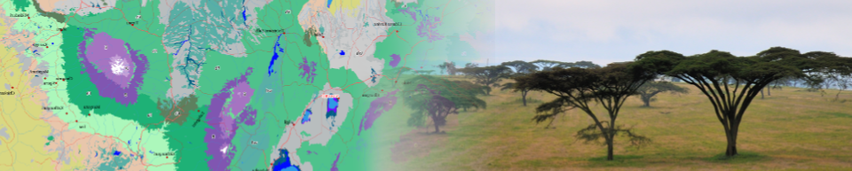
- Shorelines of Lake Victoria, Lake Magadi and Lake Baringo were corrected based on the Global wetland database (GLWD) vector layer, as shown on this image. All areas classified as water by the GLWD were classified as such on the new PNV map. The areas mapped as water on the PNV version 1.1 map but not on the GLWD map were reclassified based on their nearest neighboring on-land raster cell on the PNV version 1.1 map.
- Various smaller boundary corrections based on landscape features clearly visible on Google Earth (lake shorelines, riverine vegetation).
- Update of the PNV fact sheets and added for each PNV (1) statistics on the percentage of surface area that are within the protected areas network, and (2) list of characteristic and occurring species
Version 1.1
Version 1.1 was published on this website on 15 August 2012. Main changes are listed below. For more details, see the description of the changes in version 1_1.pdf.
- Correction boundaries vegetation types around Maralal, Kenya
- Corrections vegetation boundaries in Lakipia, Kenya
- Changes in the vegetation classification of vegetation in the northern Kenya-Uganda boundary region
- Changes in the boundaries and classification of the mountainous vegetation on Mnt Kilimanjaro and Meru
- Reclassified areas with an annual rainfall < 175mm as desert
Version 1.0
Published in October 2011 as Google Earth layer and FLD publication (volume 1). The making of the map is explained in the FLD publication volume 6 (see the documentation page).