Species selection tool
Introduction
To help farmers, foresters and others to ‘find the right tree for the right place’, a species selection tool was developed which provides information about tree and shrub species that have been documented to be useful to farming or pastoral communities. The tool provides an easy way to quickly find information about species that can potentially occur in any selected location, based on their documented occurrence in the different potential natural vegetation types. The tool is available for Google Earth and is part of the Vegetationmap4africa web-based map (note, the latter is in maintenance and is currently not available).
Using Google earth
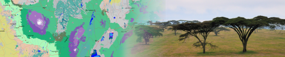
The species selection tool for Google Earth provides the potential natural vegetation (PNV) map as Google Earth layer overlaid by point layers with “clickable labels” that approximate the distribution of vegetation types for a particular country.
Burundi | Ethiopia | Kenya | Malawi | Rwanda | Uganda | Tanzania | Zambia | Region
To use the tool, select your country of interest above. This will download a Google Earth KML file. If you have installed Google Earth Pro, the downloaded layer will automatically open in Google Earth.
Alternatively, you can start Google Earth in your browser. Next, click on Projects (5th icon in the side bar), and next click the button New Project. Select the option Import KML file from computer, and open the KML file you just downloaded.
- This will start Google Earth and open a layer with clickable layers and the vegetation map (if not open already, click the link to “VECEA” available next to the name of the target country
- Zoom in to your area of interest and click on the label for the vegetation type (for the regional map, click on the letter codes). This will open a fact sheet with information about the selected vegetation type, including a concise floristic and physiognomic description and a list of species occurring in the vegetation type.
- The list of species is based on the list of “useful species” in the Vegetationmap4africa documentation that accompany the potential natural vegetation map (see the documentation page).
- Open the interactive Excel workbook that accompanies the vegetation type. This will provide a list of species naturally occurring in the selected potential natural vegetation type.
Use the web interface
The tool is also integrated in the online Vegetationmap4africa potential natural vegetation map. Just open the map (click here) and go to the area of your interest (you can move around the map and zoom in and out using your mouse).
We are currently updating and redesigning the online map. Use the species selection tool in Google Earth instead (see above).
Clicking on the map will open a pop-up balloon in the upper right corner with a link that, when clicked, will open the fact sheet with information about that particular potential natural vegetation type in a new tab, including a list of species naturally occurring in the selected potential natural vegetation type and an interactive Excel workbook which can be used to select species based on their potential use. See also this overview.